Explore Geography Highly Commended For Blending #EdTech Seamlessly Into The Learning Experience

We are delighted to announce that our Explore Geography resource produced in partnership with Inspyro has been awarded a Highly Commended award at this years prestigious Geography AssociationPublishers’ awards.
The judges felt that this was a visually engaging resource which would provide the ‘wow’ factor for KS2 or KS3 students and a way in to exploring complex processes and concepts. Overall, a professionally produced resource which has the potential to engage a range of students.
Explore Geography aims to demonstrate Geographical concepts that are studied at KS2, KS3 and KS4 in a visual and interactive way making use of the latest technology.
The National Curriculum for Geography at all Key stages states that: A high-quality geography education should inspire in pupils a curiosity and fascination about the world and its people that will remain with them for the rest of their lives.
This statement is at the heart of this resource, Augmented Reality can help convey a complex concept like no other technology and Explore Geography does this with 9 different concepts.
We believe in blending technology seamlessly into the learning experience, ensuring that when technology is used in the classroom, it enhances pupils’ learning whilst still providing the engagement and wow factor.
The ‘Active worksheets’ have the AR triggers embedded so they can be printed out and distributed to students to support group or individual investigations.
They cover a range of topics and concepts within both the KS2 and KS3 curriculum and are perfect for using to cover specifications of the GCSE curriculum with students.
Spinning Planet looks at the Coriolis effect and is an interactive 3D model of the globe with students able to observe Hurricanes, Cyclones and Typhoons in action across the globe. With a Divided Planet, an interactive 3D model of the Earth enables pupils to examine lines of longitude and latitude alongside the tropics and Equator, these can be switched on and off and highlighted, something you are just not able to do on a physical globe or diagram.
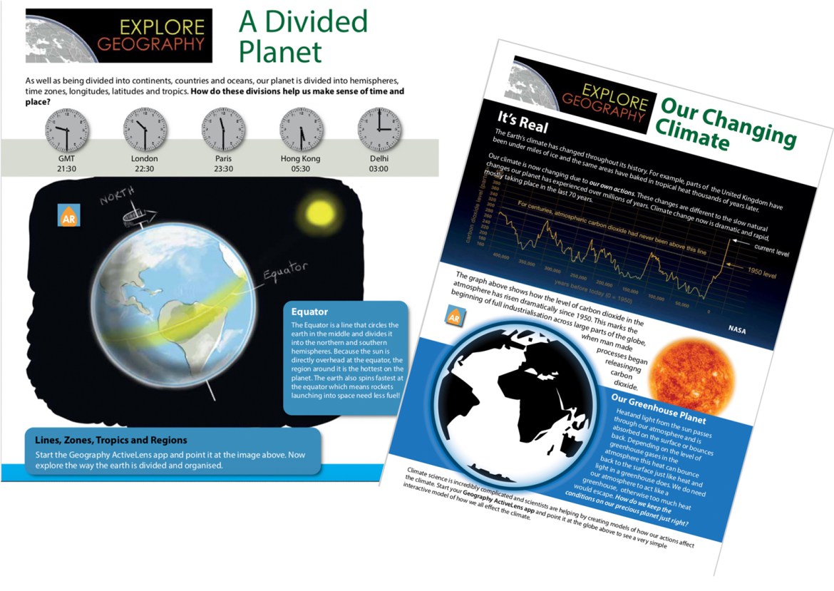 Urbanisation triggers a mini app allowing pupils to control and view the effects of over time of urbanisation with a focus on key urban development variables and ‘tipping points’. Pupils can hypothesise about urban growth and can develop a deeper understanding of how the development of a sustainable urban environment has to be carefully balanced. Enabling group discussions around what happens to an area as it becomes urbanised. It also enables pupils to explore what kind of developments take place and how it affects the population, the environment, the economy and the social structure. Our Changing Climate tackles an incredibly complex subject matter of climate science through an interactive mini app that is triggered which allows pupils to see the effects of climate change to this point and then model the possible outcomes on certain elements such as temperature and sea level over time, something again that more traditional methods of teaching can not convey.
The Explore Geography resource features context based resources that are a blend of clear and concise information and cutting edge Augmented Reality technology on the same page. A teacher guide is provided with instructions for activities the class can complete, or the resource can be used as a starting point with teachers developing their own lessons around them. The free Geography ActivLens Augmented reality app for ioS and Android brings the information sheets to life with videos, audio, 3D models and animation.
‘The Explore Geography resource is designed to help students and teachers understand a range of fundamental geographical principles and ideas that some students find difficult to grasp. For example, seeing the water cycle in 3 dimensions really helps explain the inter relationships between each element. It is no longer necessary to have to use abstract descriptions such as ‘along the corridor and up the stairs ‘ when teaching grid references as the app shows live how grid references work when applied directly to a OS map. We commission resources that harness the power of modern technology to benefit all learners and help all children achieve their full potential. We are delighted that the Geographical Association have recognised the quality of the resource we produced with Inspyro to help achieve this aim.’
Bob Usher – Content Manager LGfL






Responses